 Applied Conservation works with public land management agencies, private landowners and multiple stakeholder to restore hundreds of thousands of acres across the country to a healthier ecological condition.
To support this goal, Greg Low, along with Dr. Louis Provencher (Director of Science at The Nature Conservancy’s Nevada Chapter), and Susan Abele (currently US Fish & Wildlife Service in Nevada), developed the concept of Landscape Conservation Forecasting tm .
Landscape Conservation Forecasting is used to assess current ecological conditions, forecast future conditions, and develop conservation strategies that achieve the greatest benefits for the lowest cost. Landscape Conservation Forecasting:
- uses satellite imagery to assess the health of existing vegetation communities;
- employs predictive ecological models to demonstrate how those communities will change over time;
- utilizes computer simulations to assess how alternative management actions can influence those changes; and
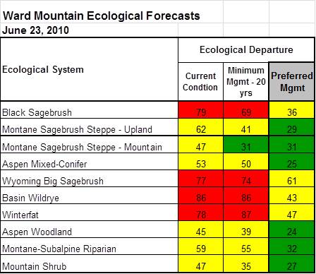
- measures success by calculating an ecosystem’s departure from its natural range of variability (and other customized metrics), with and without various management actions.
- evaluates the cost and benefits of each strategy in order to help land managers prioritize on-the-ground actions to get the highest conservation return on investment.
When used by any land management agency – Landscape Forecasting identifies strategies that can be easily embedded in the agency’s plans, provides a science-based foundation for NEPA documents, and positions the agency to be eligible for additional funding sources.
Greg Low’s presentation at the State-and-Transition Landscape Modeling Conference in Portland, OR offers a primer and examples of the process at landscapes across the country.